Snowpack & Conditions Report - 251103

Snowpack & avalanche Conditions Report
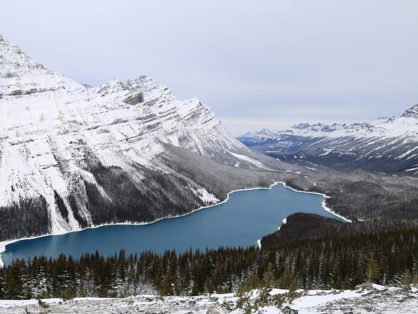
Bow Summit and the 93N - 251103
Welcome to the start of the 2025/2026 winter season! Snow has begun to fall, ice is forming, and the usual seasonal flood of ski movies and stoke reels is in full swing. But the big question remains: is it really winter yet?
A team of our guides headed out to Bow Summit today along the Icefields Parkway (Highway 93N) to take the pulse of this young season and see how things are shaping up.
With it still being early November, Avalanche Canada has not yet begun issuing daily forecasts, and formal observations remain few and far between. In their absence, social media hype, hearsay, and hyperbole tend to fill the gap, often without telling the full story.
Our goal is to help reduce that uncertainty. Below you'll find some of the observations we gathered today in the field, along with imagery from other key venues in the area to assist in painting a clearer picture of the current state of the backcountry.
WHAT WE FOUND
Perhaps unsurprisingly, Bow Summit was our target venue today. For many early-season backcountry skiers in the Bow Valley, it's often the first pilgrimage of the season and for a good reason!
Bow Summit offers easy access, a high trailhead elevation, and sits conveniently on the west side of the highway. These factors make it one of the more reliable zones for early snow coverage and quick assessment windows when conditions are still evolving.
Once on site, we followed the standard Bow Summit approach. It was immediately clear that winter had at least started to show up. Roughly 35cm of dry, low-density snow covered the road leading to the upper summer parking lot, making for a pleasant reintroduction to trail breaking. As we gained elevation, snow depths increased accordingly, and we consistently found between 50-80cm of snow at tree line.
Our crew, admittedly pessimistic at the outset, was pleasantly surprised by what we found. Many of the classic early season features appear to be filling in reasonably well, and we found ourselves shifting from skeptical to cautiously hopeful.
That said, snow depth by itself is only part of the equation, and it needs to be considered in the context of the time of year. While some terrain is holding snow, that doesn’t necessarily mean it's ready to ride. A supportive base is still lacking, and many other features have been stripped bare by wind. Where snow does exist, small trees and rocks are often poking through—or poorly hidden just below the surface.
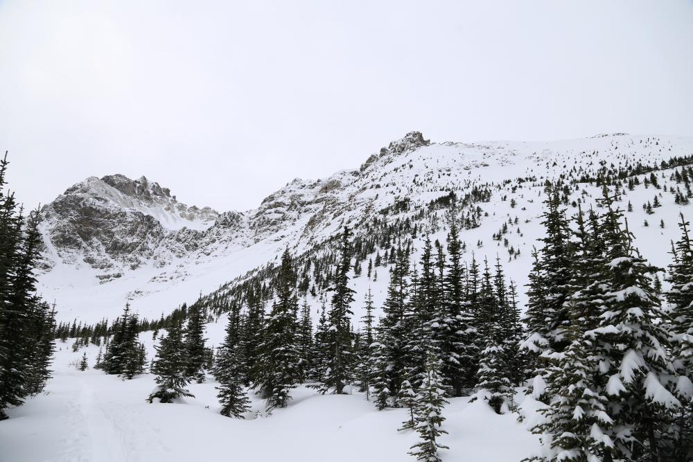
Looking up at Bow Summit from the summer trail
SNOWPACK SYNOPSIS
Given the observational nature of our first outing of the season, we felt it prudent to gain some initial snowpack data that we can use as a baseline for the rest of the season. Despite the fact that there is not very much snow to talk about, any observations are useful at this point.
We found several, easy results in the top 10-15cm of the most recent storm snow with the earlier October 17th snow down 25-30cm. The base of the snowpack consists of melt forms and depth hoar within the bottom 7cm. This snowpack progresses from F(ist) hardness at the top, 4F(inger) hardness below, and then back to F at the bottom. For those unfamiliar with the usage of appendages to describe snow hardness, this means we presently have an upside-down snowpack--a layer structure typically conducive to instability.
Unfortunately this snowpack makeup is fairly typical in the Rockies and far from unusual at this point of the season.
Elsewhere we observed evidence of wind effect suggesting that wind-loaded pockets are likely present.
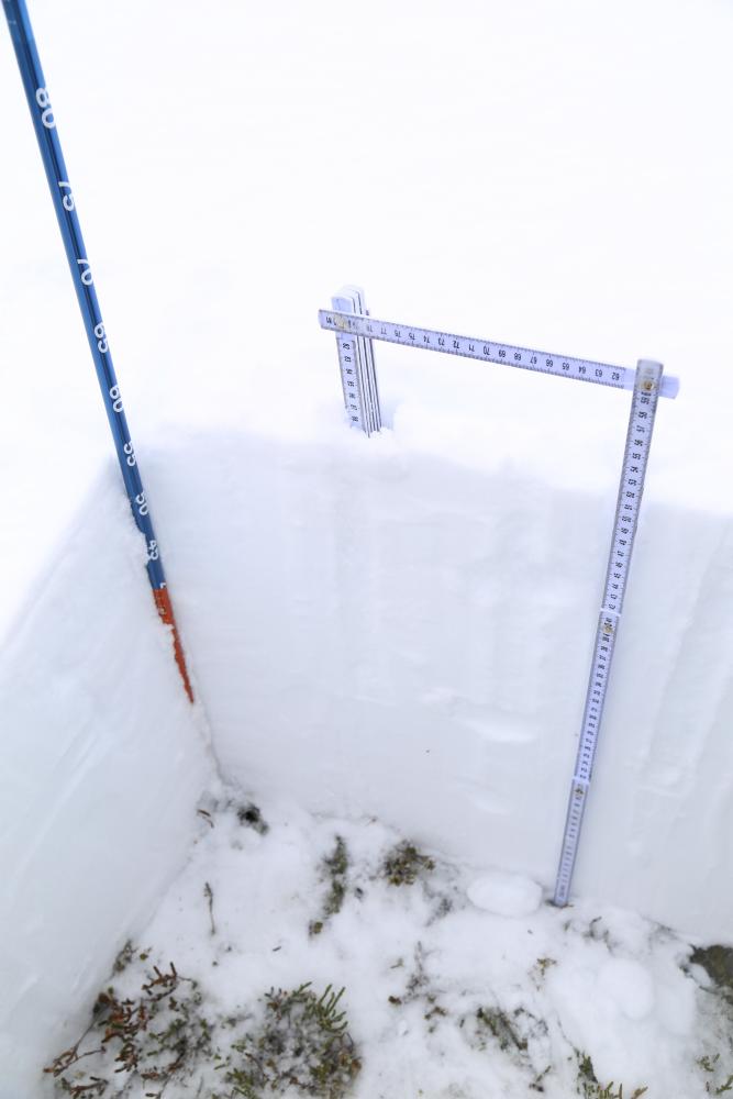
Current depth of snow. NE Aspect, Treeline
AVALANCHE OBSERVATIONS
During todays outing, visibility as a whole was fairly limited due to low light, however, the team did notice one natural avalanche (Size 1.5) on Bow Summit's North Shoulder, which had occurred in one of the earlier storm cycles. This goes to show that despite juvenile conditions, avalanches are still possible.
If there's enough snow to ride, there's enough to slide!
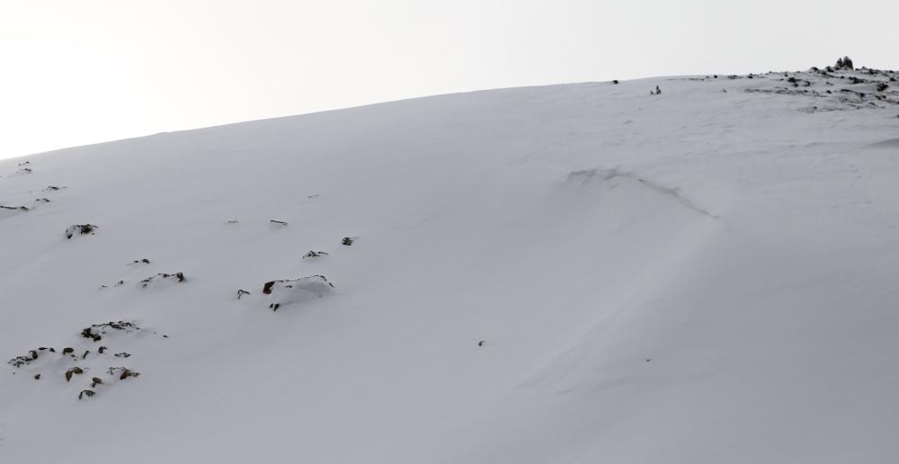
Bow Summit N Shoulder Crown - 251103
ROAD PATROL
After skiing, we took several photos of some of the most popular ski venues along the 93N. You will find these photos below.
The most notable take aways are:
- The East side of the Highway is (predictably) very thin and will require a long time before it is ready for first tracks.
- River and lake crossings on the West side are currently aquatic in nature, and will also need a long time before they are ready.
(1) Bow Summit, (2) Observation Peak, (3) Jimmy Jr Bowl, (4) Jimmy Jr Peak, (5) Crowfoot Alpine Fans, (6) Crowfoot Glades, (7) Puzzle Peak
THE OUTLOOK
It is still early days, and all good things come to those who wait.
While it is tempting to chase those first turns, early-season skiing is often defined more by what lies under the snow than what is on top. Hidden rocks, stumps, and variable coverage are widespread, and a season-ending injury at the start of November is likely not worth the price of admission.
That said, this is the perfect time to start dialing things back in: shake the rust off your setup, finally throw on that "summer" wax you have been putting off, or log a few strength sessions to wake the legs back up. It is also a great window to dust off your transceiver, brush up on rescue skills, and run some practice drills with your partners before things really kick off.
Sunshine Village opened yesterday, Lake Louise fires up tomorrow, and even the Mighty 'Quay is starting to dawn its winter finery. Resort laps might be the best way to scratch the ski itch, while avoiding the hazards of a thin backcountry snowpack.
As for our guiding team, we will be holding off for now, waiting on the next meaningful pulse of precipitation before heading out for another ski day. Until then, we will be watching the skies and keeping you posted.
The C9G's