220312 - Snowpack & Conditions Report

Snow & Avalanche Conditions Report
Rockies - 220312
Our Guides have just wrapped up a week or so in and around the Banff, Lake Louise and Icefields Parkway south venues, and have a few notables to pass on for those interested.
Despite the Public Avalanche Bulletin reporting mostly Moderate Hazard and lower, we've been bearing in mind that we're just rolling into a period known to many of the old guard forecasters as the Ides of March. Historically, the next few weeks has been a period during which uncertainty experienced is often higher, and historically has the distinction of being the two and a half weeks of the winter season where an atypical number of close calls and fatalities often occur.
Perhaps it's debatable, but it's been proposed that the current period, as it rolls by each season, is typically a point in the winter months where substantial or a mature snowpack load exists, however has not been tested by the stresses of early spring weather inputs such as increased radiative inputs, and day time temperatures. Headed out last week, despite the promising looking Public Avalanche Bulletin inputs, this was front of mind.
AVALANCHE OBSERVATIONS.
Aside from catching wind of the skier accidental size 3.5 down the road on Vermillion Peak, we had a couple odd ones hit our radar during the course of programming.
Wawa Ridge - West Asp. 2400m - Skier Accidental - Size 1.0 - 220310
In a fairly typically thin, bouldery and heavily facetted area just below treeline, one of our Mountain Guides, traversing into the start of a line, had both skis drop out into a large weak facetted pocket below and hit the proverbial land mine. The collapse was followed by a substantial wumph, which was felt by the guests positioned approx. 30m to the side of the entry to the line. A small 15m x 15m slab partially released immediately above the Guide, likely down more than 1m, but immediately hung up in place sliding into more supportive snow below.
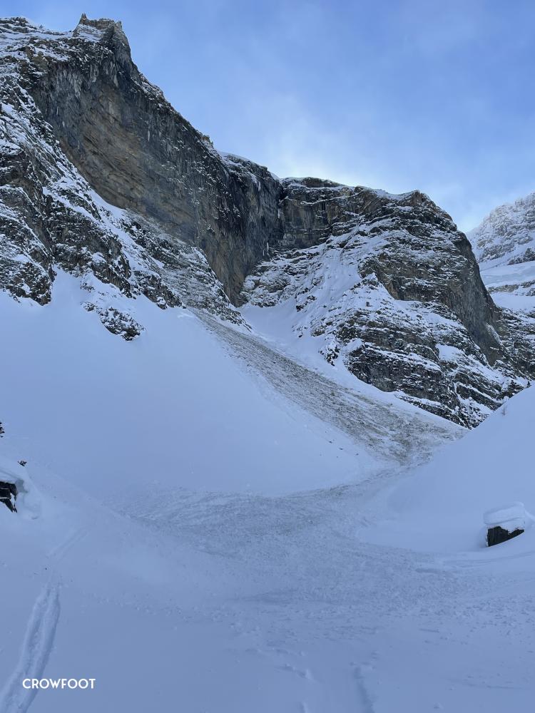
Crowfoot Glades - North Asp. 2500-1900m - Natural Avalanche - Size 3.0 - 220309
This one was a bit of an annomoly. Our Guides have never seen this feature hit the runout zone, and in this instance when it did, it managed to leave about 1m of debris on a common uptrack near the moraines where folks depart upward into the trees on ascent. Further, it appears as the slab from overhead released, it likely almost immediately became airborne and landed on a lower angle bench coated in loose rock some 200m below. The impact force seems to have stripped much of these ledges clean, entraining a substantial amount of rock debris in amongst the avalanche debris. A portion of the debris managed to jump the upper skiers left side of the moraine while the bulk was diverted along it's broadside down toward the uptrack (photo).
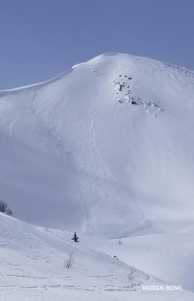
Hidden Bowl - North East Asp. 2550 - 2400m - Natural Avalanche - Size 2.0 - 220311
Having spent the day in the Corral Chutes area on the 10th, wind effect in the upper start zones was limited. Arriving back in the same venue on the 11th, transported snow was ongoing and evidence of a natural sz. 2.0 avalanche just above hidden bowl was observed. We've skied this line a few times with guests over the years, but rarely with PWL's in the pack, and typically during periods of low hazard as the line can terminate in a hundred foot deep toilet bowl, and is not a place we'd be overly enthused about "getting it wrong". Assuming given the high likelihood of triggering this new WSL will remain for a few days, not sure we'd be back to the Corral area until this new problem bonds and heals up.
SNOW PROFILES (WORTH SHARING).
Corral Chutes 1 - Upper Start Zone - 2500m - E Asp - 35˚ - Open Alpine / Heavily Crossloaded - 20220310
51°28'9.20"N 116° 6'54.94"W
CTE4 Down 15 RP (WSL)
CTM17 Down 80 SP (February 14) Suncrust, Facet Combo.
Crowfoot Glades Moraines - Valley bottom - 1950m - E Asp - 30˚ - Moraine feature, var. loading - 20220309
51°38'56.25"N 116°25'44.78"W
ECTX - (no results)
CTM14 Down 60 RP (February 14) Facets 1-2mm above the crust.
LOOKING INTO THIS COMING WEEK.
Our main concerns looking into this coming week would be 2 fold. Lingering reactivity in new WSL problems in the immediate lee of ridgecrest, and crossloaded features, with continued development as new wind and snow events arrive this week - and risk of these potentially stepping down to the February 14th PWL. Looks as thought the sun may be a bit less of a factor, but worth monitoring regardless in the coming week.
We'll be mindful of any environmental stress on the pack that could serve to increase likelihood of triggering (ie: wind and precip primarily - and the solar if it makes an appearance), and be willing to step back in tandem with stress increasing just to give the snow pack a chance to tip it's hand before stepping back out particularly in the alpine. Looks like plenty more wind and snow in the forecast this week, so might be the opportunity to do just that.
Snow quality has been great much of the past week, and looks like that'll continue here for at least the next few days.
All that said, most of the team is off to Fernie for the week upcoming - so we'll see what it all looks like when we're back!
Have a great week out there.
The C9G's
WHERE WE WENT, AND DIDN'T.
Often the first aspects to be tested during the Ides are the south, south west, and west aspects. The sun is definitely kicking out there now, and we're about a month into the suncrust season - it seemed prudent to heed the warnings in the Banff, Yoho, Kootenay PAB forecast, and stay off slopes that would be likely to take a solar induced kicking during the hottest hours of the day. Radiative stress is a hard thing to assess, and almost always comes with some varying levels of personal uncertainty as to actual amounts of stress inputted to the pack. An easy way to think of it; tip your face into the sun - if you're goggle tan is coming in, that same radiation is going to affect the snow. Think twice if you're proposing dropping into a line with terrain magnitude sufficient enough to end your story, particularly with the PWL in the pack at present.
Where we did aim to spend the majority of our time early this past week was N-NE, alpine and particularly, and managed to push uniform, or supported slope angles up to about 40˚ in open alpine terrain early in the week in a variety of terrain. That said, there was significant spacial variability in our snow profiles and we dug nearly every day, often multiple times, to confirm the presence and strength of potential problems (layers) before committing to anything of consequence. And in a few instances even backed off due to a handful of disconcerting results.
Ski / ride quality on the N-NE was tip top early in the week, with great quality riding on mostly sheltered features again in the alpine and at treeline. Thursday night (March 10th) a solid wind event laid down new WSL in alpine, immediate lee and crossloaded features and had us pulling the reins in soundly during the day Friday. This new WSL is likely to remain reactive through the weekend given the forecast.
Our venues were primarily located in the Lake Louise and Sunshine backcountry, and areas near to Crowfoot along the Icefields Parkway 93N.